This article is more than 1 year old
If you want to take social distancing to the next level, and go to the Moon, take this: A complete lunar geology map
First-of-its-kind blueprint of materials and structures shared online
Video The United States Geological Survey (USGS) has published the first-ever comprehensive geological map of the Moon’s surface.
USGS geologists worked with astronomers at NASA and the Lunar Planetary Institute in Texas to piece together the digital map from a variety of resources, including readings from six Apollo missions and more recent lunar probes.
“This map is a culmination of a decades-long project,” Corey Fortezzo, USGS geologist and project lead author, said this week. “It provides vital information for new scientific studies by connecting the exploration of specific sites on the Moon with the rest of the lunar surface.”
Datasets from NASA’s Lunar Reconnaissance Orbiter’s Wide Angle Camera and Lunar Orbiter Laser Altimeter, which detail the Moon's nooks and crannies, contributed to the project. Other spacecraft, such as Japan’s Selenological and Engineering Explorer (SELENE), provided topographic data for the north and south poles.
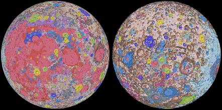
The result is the Unified Geologic Map of the Moon, which you can download from here when the USGS website is working. It is effectively a color-coded blueprint of the patchwork of rocks, materials, and structures that make up the surface of Earth's natural satellite.

Orthographic projections of the Unified Geologic Map of the Moon showing the geology of the Moon’s near side (left) and far side (right)
Credit: NASA/GSFC/USGS ... Tap for larger sizes
The map “consists of 43 geologic units across the entire lunar surface,” according to a paper produced by the team for the 51st Lunar and Planetary Science Conference expected to take place virtually today. “These units are broken down into groups based on attributes and include materials of craters, basins, terra, plains, Imbrium Formation, Orientale Formation, and volcanic units.”
Below you can see the unified map projected onto a rotating Moon:
“People have always been fascinated by the Moon and when we might return," said USGS Director Jim Reilly, a NASA astronaut who flew on three space shuttle missions between 1998 and 2007. “So, it’s wonderful to see USGS create a resource that can help NASA with their planning for future missions.”
If you're wondering about the colors in the map, Jim Skinner, a research geologist at the USGS Astrogeology Science Center, told The Register:
The colors on the map represent the discrete geologic units of the Moon that are discernible at a map scale of 1:5,000,000 ... that is, 1 mm on the map equals 5,000,000 mm on the lunar surface (5 kilometres).
[It] provides an important template for lunar exploration because it enables local regions, such as those that might be explored by astronauts, to be studied in detail while simultaneously allowing correlation to other areas on the lunar surface. Thus, scientists can be sure they are referencing the same rock unit. This may also lays the foundation for starting discussions about resources that can make sustained exploration of the Moon a reality in future years.
In related Moon news, astronomers have spied their hundredth lunar asteroid collision. The European Space Agency’s NELIOTA project studies near-Earth asteroids and their prangs with the Moon.
Scientists use a 1.2-metre telescope at the Kryoneri Observatory in Greece to capture the collisions. They observed a characteristic flash of an asteroid crash landing on the Moon's surface last month, and the Sharjah Lunar Impact Observatory in the United Arab Emirates confirmed it was the hundredth collision seen so far. ®
